What is a “Slow” Process in a Source-to-Sink System?
The timescale of geological processes is very extensive. “Fast” processes like earthquakes, storms, or tides last from a couple of minutes to weeks. “Slow” processes, like orogenic uplifts or continent break-ups on the contrary can take up to millions of years (Fig. 1). In this post we will look into these slow processes in the context of the source-to-sink approach, introducing some concepts that provide a useful framework to understand the dynamics of these long processes in sedimentary systems.

Figure 1. Temporal scale showing the differences in terms of duration of several geological processes as well as the common tools used to measure them. Bear in mind that the scale is logarithmic. Modified from Romans et al., 2016.
To understand slow geological processes in the
context of source-to-sink analysis, we first have to understand the concept of steady-state
topography. There are two major processes that drive topography inside a catchment
(Fig. 2), one that creates positive relief (uplift) and one that breaks it
down (erosion). A landscape is said to be at a steady-state when erosion and
uplift are equal, this means it has reached a point of equilibrium and there
are no further changes in the mean topography. This is important because there
are still changes in topography in parts of the landscape, but the average
remains the same. When a perturbation is introduced, depending on the
perturbation time, it might take a long or short time until the landscape reaches
a new equilibrium - this is then considered to be a transient state. The
reason why transient states exist is that landscapes respond gradually to
tectonic and climatic perturbations - think about humans, when we arrive in a
new environment we also need time to acclimate to these new conditions.

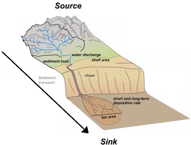
Figure 2. Plan view of a source-to-sink system. The catchment
is the area where sediments are produced as a result of denudation processes,
which are driven mainly by tectonics and climate. Note that the zones are
up to scale, meaning that the catchments are usually the biggest zone within
the system. Taken from Martinsen et al., 2010. For further information about
the source-to-sink morphology check out our first blog.
The perturbations introduced to the system are defined as allogenic (i.e. coming from outside of the system) or autogenic (i.e. coming from inside). The most important are tectonics and climate; both are allogenic. Tectonic perturbations are more prominent at convergent plate margins (where mountains are formed) and divergent plate margins (where continents break up). They are also relevant in places where the interior dynamics of the Earth's mantle affect the outer crust and create large uplifted zones independent of plate boundaries (Fig. 3). These perturbations are slow processes that take several million years to occur, which cause significant long-term disruptions in factors like topography, erosion, weathering, and sedimentation rates. A clear example might be a continental collision zone that creates a new mountain range through uplift, causing an increase in erosion and sediment fluxes in the system. The duration of the transient state is directly proportional to the geometry of the catchment – in other words, the bigger it is, the longer it takes for a new steady-state to develop. This is also called a landscape response time or equilibrium time.

Figure 3. Schematic illustration of the three main settings
where tectonic perturbations take place A) Convergent plate margins B)
Divergent plate margins C) Dynamic topography or uplift zones created by large
systems of mantle upwelling, which are not necessarily related to a plate
boundary zone. Note in A) the representation of the steady-state, where erosion
and uplift is equal and thus the mean elevation (z) does not change.
There is an important relationship between the
duration of the perturbation and the landscape response time (Fig. 4). The key
point is that since the duration of these slow changes is much longer than
typical landscape response times, systems often end in a permanent state of
adjustment to the continuous changes in the external parameters.

Figure 4. Shows the ratio between the timescale of a perturbation and the
characteristic equilibrium, or response time of a sediment-routing system. The
landscape response (for instance, in sediment flux rates) will tend to
gradually match the original, external parameter change for perturbations
longer than the equilibrium time. For perturbations faster than the equilibrium
time, there is not enough time for the entire catchment to adjust to changes,
and only a “buffered” response is registered. Modified from Romans et
al. (2016).
In continental areas, the geometry of river
profiles can be correlated to the state of an entire catchment. Field
observations have discovered that river profiles are dynamic features that
constantly adjust to changes in external parameters at various temporal and
spatial scales. Rivers are the points of lowest altitude inside a given
catchment, where all sediment transported from adjacent hillslopes eventually
converges. The increasing uplift rate of an entire catchment causes overall elevated
river profiles. This is accompanied by a break in the river slope due to the
incision of a new, steeper river profile, directly related to the new base
level. In geomorphology, this break in slope is often called a “knickpoint”,
and it is a very important component of natural river profiles that can tell us
about the history of past changes in external parameters (Fig. 5). During this transient state of increasing uplift rate, rivers will incise the underlying
bedrock more and then gradually produce more sediments, which are eventually
transported to the depositional sink. As a result, we can measure a
corresponding increase in sediment fluxes in sedimentary basins.

Figure 5. This animation showcases what happens to a landscape when there is an
increase in the uplift rate. Because erosion rates will tend to match uplift over
time, the landscape adjusts by increasing its overall slope. With steeper
slopes, more material is eroded and transported. This animation was done using
a Python library called Fastscape (Braun and Willet, 2013; check the script at https://github.com/fastscape-lem/s2s-future-dragonstone in the signal propagation folder). Note: the graphic does not include
the increase in sediment flux that would also be created by a change in the overall
catchment area.
Climate changes also have a direct impact in
denudation processes (erosion and weathering). Cooler and drier conditions
usually decrease the rates of denudation, while hotter and more humid
conditions do the opposite. This has an impact on all kinds of landscapes as
well, which can be studied through the identification of weathering profiles
(previous soil layers that act as records of environmental conditions)
Climatic perturbations are often linked to tectonic perturbations, which sometimes makes it hard to distinguish the signals. An example is the break-up of two continents. This causes volcanism and the release of CO2, thus increasing the temperature and changing the climate, which similarly results in an increase in weathering and erosion rates. If these changes are gradual enough to last longer than the equilibrium time of a given landscape, then a characteristic record will be created in adjacent sedimentary basins (Fig 4.) Similarly, even if short period climatic perturbations might sometimes not be completely translated to sedimentary basins, evidence of fast climatic change can be scattered in multiple kinds of records, such as weathering profiles, successions of chemically precipitated sediments, fossils, etc. This is where the source-to-sink approach comes in handy, as it is a holistic approach that allows us to connect the causes and consequences of specific processes in different temporal and spatial scales, using and combining multiple branches of geoscientific tools (see our second blogpost for reference).
Why is this important?
Predicting sedimentary basin characteristics
during resource exploration:
Sedimentary basins are the
hosts of natural resources like petroleum, water, coal, uranium, and many
others. Nowadays, they are also targeted as potential reservoirs for CO2 storage, which can help mitigate the effects of
fossil fuel usage on climate change. In order to explore these natural resources,
geoscientists and engineers need to predict the subsurface characteristics of
sedimentary basins, as we typically can not access them directly.
In a source-to-sink
context, sedimentary basins act as an incomplete record of changes that took
place in the source area, which, for ancient sedimentary basins, is typically
not preserved anymore. Slow, long-term geological processes that affect source areas
can directly impact the physical properties of rocks inside sedimentary basins,
including those related to the disposition and exploitability of any natural
resources. For example, the balance between different source areas (often there
is more than one for a single system) may change over the course of several
million years and this can affect not only sediment composition but also the
stacking patterns of different layers of sediments - in geology, this is called
stratigraphy.
The source-to-sink analysis allows the identification
and interpretation of the fundamental mechanisms behind landscape evolution, as
well as the contemporary formation of sedimentary basins. This framework
of knowledge allows us to more accurately connect processes from depositional
sinks to source areas, permitting integrated predictions of basin stratigraphy,
which are key for resource exploration and production.
Climate and landscape
evolution:
In the context of climate
change, it is important to predict how the landscape will respond to
perturbations. Landscape modifications driven by river catchments have
socio-economic implications. Changes in erosional and depositional patterns
greatly affect drainage basins which are fundamental for the development of
human infrastructures. Climate change multiplies the risks of shoreline
migration, long-term sea-level rise, modification in ocean currents, and others,
which directly impact large areas of human settlement. Another important
application in the current climate change crisis is a deepening in
the understanding of the carbon cycle and the impacts it has on regional
climate and flora. This can assist governments to define better environmentally-conscious based policies.
If you have any questions
about the dynamics of these slow processes in the source-to-sink systems,
please leave a comment below! Thank you for reading
and see you next month for the next post!
References:
Romans, B. W., Castelltort, S., Covault, J. A., Fildani, A., &
Walsh, J. P. (2016). Environmental signal propagation in sedimentary systems
across timescales. Earth-Science Reviews, 153, 7-29.
Martinsen, O. J., Sømme, T. O., Thurmond, J. B., Helland-Hansen, W.,
& Lunt, I. (2010, January). Source-to-sink systems on passive margins:
theory and practice with an example from the Norwegian continental margin. In
Geological Society, London, Petroleum Geology Conference series (Vol. 7, No. 1,
pp. 913-920). Geological Society of London.
Braun, J., & Willett, S. D. (2013). A very efficient O (n), implicit
and parallel method to solve the stream power equation governing fluvial
incision and landscape evolution. Geomorphology, 180, 170-179.
Excellent!!
ReplyDeleteReading this felt like finding a forgotten path in a familiar forest—full of unexpected turns and quiet revelations. It’s the kind of perspective that lingers long after the last word. 🌙 darknet market list
ReplyDelete