What is a Source-to-Sink System?
A source-to-sink analysis is a method in
sedimentary geology that integrates the studies of an entire sedimentary system
from its upstream source in the continental area to the ultimate
depositional sink, most commonly on deep basins, in a process that can take from thousands
to millions of years to be completed.

There are three main elements in the source-to-sink system, source, transfer zone, and sink.
1) Source
Source area in the source-to-sink system is in
the continental realm where the main erosional processes occur. The erosion
process in the source area is mainly driven by slow processes which can take
millions of years: tectonics and climate. Tectonics generates high relief
structures like mountains while climatic factors like precipitation bring water
down the mountains. Hence, more sediment supply can be provided from the source
area.
During the erosion processes, a rock will be broken down into
smaller disintegrated particles so that they can be transported by water, air
or ice as the transport agents.
There are two types of erosional processes:
- Physical
(mechanical) erosion – the disintegration of rock into smaller fragments without changing the chemical composition. It occurs mainly by temperature
and pressure changes.
- Chemical erosion – the disintegration of a rock accompanied by changes in its chemical compositions done by interactions between chemicals in water or air and in the rock itself.

Himalayan mountain as a source of sediments and Indus River in Ladakh, India (from Britannica).

2) Transfer Zone
The transfer zone is the connection between the
source and the sink. It is the place where all the sediment produced upstream
(source) will be transported to its final destination (sink), like a conveyor
belt. This conveyor belt is called the main channel or the trunk channel, where
the other smaller rivers and brooks converge. Relief in this zone is not as
high as in the source and the hillslopes are generally smoother. Both erosion
and deposition can happen in this zone, but on a smaller scale than in the
source and sink areas. Consequently, interesting structures called river
terraces might be formed in this area.
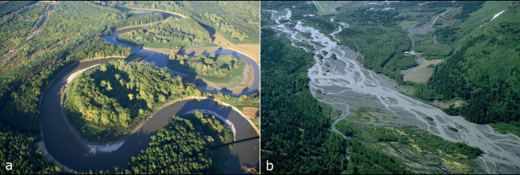
The transfer zone links the source to the sink area. Transport of
sediments through fluvial channels is the main process of this area, yet sediments
can also be temporarily stored in fluvial terraces (modified from Worldatlas).
3) Source
The sink is the ultimate destination for the sediments in this system. Hence, the main process is deposition. The sink can be an oceanic basin or a large lake. The type of deposits depends on the water energy. Sediments with coarser grain sizes like sand will be deposited close to the river mouths and those with smaller grain sizes like silt or clay in the calmer, deeper areas such as the deep sea. Storms mainly rework shallow areas e.g. on the continental shelf. In the long term, sedimentation depends on the sea level, e.g., pauses in deposition can occur in the center of the sink during the sea-level rise or a decrease of sediment supply from the rivers. On the other hand, the sediments in shallow areas will be eroded and transported into the deeper sink during sea-level fall.

As younger sediments are always deposited on top
of older ones, we can investigate the changes over time. But we need to
carefully select the position in the basin for sampling as it will affect our
investigation.
WHY IS IT IMPORTANT TO
STUDY SOURCE-TO-SINK SYSTEMS?
As a researcher, after we understand what a source-to-sink system is, we have to dig deeper into the goal of these studies: why do we do it?
There are 2 main goals in this case: (1) to fulfill our thirst for knowledge, and (2) to benefit our society.
Describing a sediment routing system, how it works and understanding why it happens the way it does and which parameters control it, helps us predict the location of certain types of sediments and resources, and better make use of our surroundings without degrading the environment.
WHAT ARE THE BENEFITS?
The 2004 Margins Program from the U.S. National Science Foundation (NSF) states that ‘’Erosion sculpts the landscape, and distribution of the sediment creates the alluvial plains, coasts, deltas, and continental shelves upon which most of the world’s population lives and derives much of its energy and water’’. Such sediment transfer from source-to-sink plays an important role in:
· The cycles of elements (such as carbon, silica, etc.);
· Ecosystem changes due to climate change and
sea-level rise;
· How we manage our natural resources, such as
soils, wetlands, groundwater, and hydrocarbons (Martinsen et al. 2010).

Nile delta and major cities - about 39 million people live within the delta region (from Wikipedia).
One of the biggest challenges in hydrocarbon exploration is: how do we select the best location to be explored? This is directly linked to the understanding of the three essential parts of a petroleum system: source rock, seal, and reservoir rock, which are mainly sedimentary rocks. Therefore, it’s necessary to have the best analysis of geological data from the complete sedimentary system (source-to-sink). The same idea can be used for the exploration of other resources, such as water, metals, sand, clay and aggregates which are often hosted by sedimentary rocks. By understanding how the deposits are formed, we will have better predictions to determine where we can find and explore them for the development of our society.
Another important part of understanding source-to-sink systems is to support the assessment of risks related to them, such as mass movements, heavy metals and other polluting substances.
Integrating knowledge from the source area to its ultimate depositional sink is an advanced and the needed approach to better understand the whole sedimentary systems nowadays rather than putting them into separate individual aspects. This approach will both nurture our science and society towards a more sustainable future.
If you have any
questions about source-to-sink, please leave a comment below! Thank you for reading and see you next month
for the next post!
References:
Martinsen,
O., Sømme, T. O.,Thurmond, J. B., Helland-Hansen, W.,, Lunt, I.(2010). Source-to-sink systems on passive margins:
Theory and practice with an example from the Norwegian continental margin.
Geological Society, London, Petroleum Geology Conference series. 7. 913-920.
DOI: 10.1144/0070913.
Comments
Post a Comment